


Iconic Mt. Blue, a poplar Franklin County summer hiking destination, beckons to the winter hiker as well. Its stand-alone location in central Franklin County provides striking views in all directions – either from the summit lookout tower, or from the four high elevation viewpoints at the sides of the summit clearing.
Watching the weather forecast closely, I see a window of hiking opportunity – a sharply clear and cold day sandwiched between two days of heavy rain, and snowfall predicted in 48 hours. I phone a hiking buddy, recheck my “ready bag” of winter hiking gear, add food and water, and hit my pillow for an early morning start. We head for Mt. Blue State Park in Weld at first light, seeking to make good use of every bit of light available to us in this season when there are more night hours than those of daylight.
And what light we have! Sunbeams over the snow-covered hills, throw early shadows through the woods, brighten the coppery leaves of the beech trees, and cast a rich glow to the pine, spruce, and fir. We stop on route to check Wilson Stream at Bald Mountain, and find it running high, wide, and fast. Bald and neighboring Saddleback Wind Mountain are a favorite hiking combination in winter, but two days of steady rain have rendered the stream pretty dicey to cross. On to Mt. Blue – with no major stream crossings.
Our route begins at the winter-chained, unplowed, Mt. Blue Road, off the Center Hill Road in Weld. From this point it is 2.0 miles to the Mt. Blue Trailhead, a fine enough walk, or cross-country ski when the snow is right. Today the road is thinly snow-covered, with icy spots – no skiing on this trip!
Parking is the first order of business. There is little room here, as a driveway to a private home stands by the gate; and the chain-gate itself must always be kept clear in case of an emergency. (Note: Never block a gated or chained road anywhere in the Maine woods, at any hour, any season, no matter how remote. Rescue vehicles may need access.) We park to the side, leaving ample room. Parties with multiple vehicles might park at State Park Headquarters on Center Hill Road, and shuttle passengers to the gate using one vehicle.
Off we go – with flexible boot crampons on our winter hiking boots, to make our way along the icy roadway. We enter a world of continuing bright sun, low on the southern horizon, and sheer quiet. In just under an hour we reach the trailhead and snow-covered parking lot for the Mt. Blue Trail. Before starting the 1.6 mile ascent we step over to the picnic shelter at the south end of the parking area. Here we duck in from the strong northwest, clearing-out wind. I hydrate with water, and down a bagel with homemade raspberry jam.
Now the work begins, demanding careful foot placement on icy and snow-crusted trail. We both use trekking poles equipped with snow baskets. These, along with our flexible crampons, provide good purchase as we ascend over the rocky route. In a half-hour we pass the side trail to the abandoned fire warden camp, now falling in after years of no use. Above that a stream crosses the trail, but unlike Wilson Stream near Bald Mountain, the water is but a trickle under the ice, and this is an easy step-over.
The way steepens, and the going is slow. We warm up by our exertion; stop to remove a layer of clothing before going on. It is essential to avoid heavy perspiration, which can cool quickly, and bring on a chill. Both of us are dressed in layers of wicking fabric that draws moisture away from the skin.
When we reach the north shoulder of Mt. Blue, we gain a view of Mt. Abraham/Abram to the east, and have a look at Phillips and the upper Sandy River valley. This scene is a gift to winter hikers! During the summer season, abundant leaf cover on the thick stand of hardwoods along this shoulder would block that view.
The trail swings southward, continues steeply. We pick our way along, aware that ice lies under the snow – but what is the hurry? Up, up. Plant a foot, look for the next promising foot placement, push off with one of my poles, and I am that much closer to the top. One hundred feet below the summit a 30-foot side trail leads to a west facing overlook – one of my favorite viewpoints in the Western Mountains of Maine.
Wow! Before us lie Webb Lake and the Tumbledown Range, Bald and Saddleback Wind rise along the southern rim of the Weld Valley. With a stretch I gain a look at the Saddleback Range in Rangeley– clear along its full length on this bright day. To the far west rise the rugged heights of the Mahoosuc Range – and beyond those peaks, Mt. Washington and the Presidential Range. We pause here for a good while.

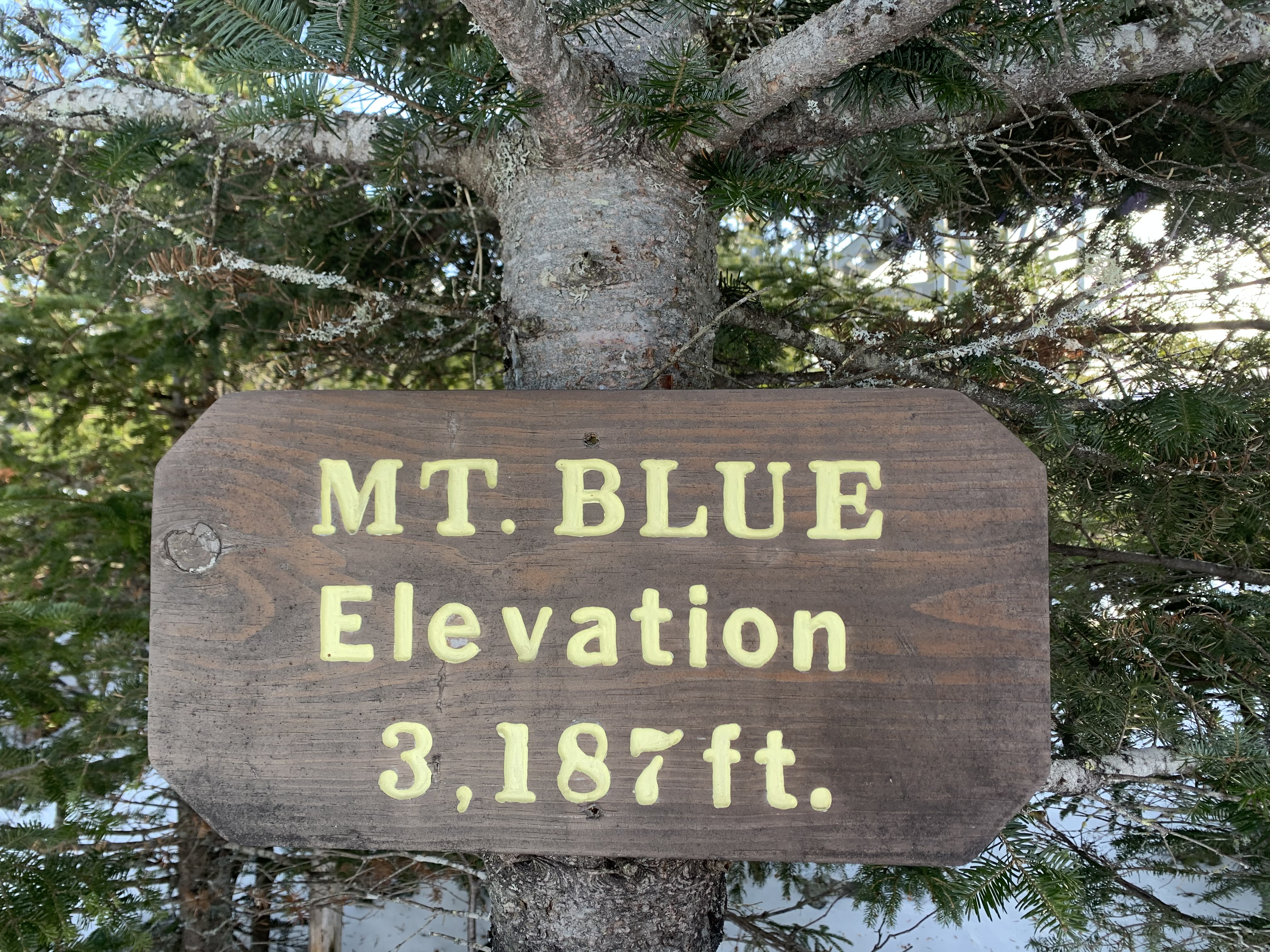
Eventually, that wind out of the northwest prompts us to move on. I am cooling off. We head for the tower, a false-fire tower design, containing communication equipment. By the base of the tower, near a “Mt. Blue 3187’” sign we pick our way to a southern viewpoint, out of the wind, break open lunch. I have carried a section of closed cell foam to sit on, and open that up to keep myself off the snow. Time to break open a container of hot tea, and down some whole-wheat mac and cheese I had cooked up at home for this moment.
Far to the south the view extends in an unbroken plane beyond the hills of Strong and New Vineyard. Somewhere out there is southern Maine and the sea. Another discovery, – far to the southeast rise Mt. Battie and the other peaks of the Camden Hills! Not done! Beyond these, more easterly still, stands the distinctive profile of Cadillac Mountain in Acadia National Park. On this clear day we do just abut see forever. Quite the sight!
Time to descend. We have spent time at two of the four lookout points, and will save the other two: east, and north, for another hike. Our ascent required 2.5 hours, in addition to the road hike of another hour. We want to keep well within daylight hours in the event of a mishap, and down we go – but with one more stop at that westward viewpoint, one more look out toward Mt. Washington.
As we drop down from the summit cone, we enjoy a surprise view that was behind us on the ascent – Mt. Blue Pond in Avon, and a fine look at Mt. Abraham/Abram. These are visible through the cut of the trail through the high conifers. We use care as we descend, as helpful though our crampons be, they can catch a root and send a hiker flying. Again, slowly with careful foot placement, we make our way to the trailhead, reaching it in just a bit over an hour. Another hour on the road footway, and we are back to the truck in good time. Total distance: 2 road miles and 1.6 trail miles one-way, 7.2 miles round-trip.
Trail Tips: Always leave a copy of your hiking plans in writing with a responsible person, including the time you plan to return, and what to do if you are late. Dress in wicking and insulating layers. Always carry a headlamp, extra water and food, a whistle, a foam pad or insulating blanket, a map and a compass, and a reliable means of communication such as a cell phone with service and/or a locator/signaling device.
We in the Western Mountains of Maine have in our backyard some of the most pristine hiking terrain in Eastern North America! Enjoy!
Doug Dunlap is a Registered Maine Guide footandpaddle@gmail.com
Text and photos – Copyright 2020
Douglas Allan Dunlap
513 Holley Road
Farmington ME 04938

Thank you for your amazing descriptions, Doug! I was with you every step of the way. With this article, as always, you are an inspiration.
Excellent article that includes thoughtful guidance for winter hiking and fabulous photographs. Thank you!
Needs more pictures
Thank you Doug. Your adventures are inspiring. My dogs really appreciate the new trails we’ve discovered while using your guide- Farmington-Wilton Walking Trails. Happy Trails!
Doug’s description is both inspiring, though possibly a bit beguiling. As intoxicating as outdoor hikes can be, especially in winter, I would urge hikers to consider one major caution. Several years ago, I was winter hiking with a friend on Bald Mountain, a very well-known mountain. On this particular occasion, equipped with mountaineering snowshoes (my friend wearing my crampons), I unexpectedly lost my footing close to the summit. In a split-second, I was rocketing down an ice-covered slope at a speed that might have given Mario Andretti pause. All I could think to do was roll to one side in what proved a futile attempt at grabbing a small bush. Instead, the branch slipped through my hand, ripping my glove. I probably slid 50 feet or more before slamming into a tree, hyper-extending my back in the process. How I survived this incident without any significant injuries is beyond my understanding. There were several lessons here. Obviously, (1) never hike without a friend. (2) Never hike on ice-covered mountains without crampons. (3) Feel comfortable on ice, especially snow-covered, before tackling steeper slopes. (4) Don’t be lulled into underestimating mountains like Bald just because they are small. (5) Recognize that mountaineering snowshoes, no matter how high-tech, are insufficient against ice. (6) If possible, try to gain some experience in using an ice-axe to arrest yourself in the event of a slide, and (7) never, EVER, lend your crampons to your friend! LOL.