


The train, in a manner of speaking, is leaving the station for the 6-mile run on the narrow gauge railroad bed down to Carrabassett Valley, on a bright and brisk winter day. There is no train in the actual sense and the “station” is simply the Highway 27 Stratton Brook Hut trailhead about 200 yards from the former Bigelow Station settlement. The steam locomotives, “Mead” and “Sargent” among them, that once hauled wood, freight, and passengers up and down this route have long since been retired from service, and the track taken up. Instead, that “train” is any of a number of cross-county skiers, those on snowshoes, and “fat-tire” bikers who take to what is now called the Narrow Gauge Pathway for a good winter outing in the shadow of Sugarloaf and the Bigelow Range.
Today, on skis, I am one of them. Departing earlier in the day from the Airport Trailhead in Carrabassett, I have made the six-mile gradual ascent to the uppermost point on “The Gauge”, near the former railroad settlement of Bigelow Station. Now, with gravity in my favor, I reverse direction for the downhill run.
The Narrow Gauge Pathway, paralleling the usually raucous Carrabassett River, has become one of my “go-to” locations. The route is thoughtfully maintained for public recreation by the Town of Carrabassett Valley, at no cost to users. The town arranges for the snow cover to be machine-groomed, with a track on one side for classic technique skiers, and a broad space for skate technique skiing and snowshoeing, on the other. The morning after a recent snowfall I phone the Town Office to confirm that The Gauge has been groomed, receive an affirmative reply, and head for the trailhead.

The “narrow gauge” term derives from the two-foot distance (actually 23 ½”) between the rails, a contrast to the 56” standard gauge widely used in North America from the late 1800’s to the present day. A story has it that a narrow gauge line was in use in Wales, Great Britain, to haul slate and passengers through rugged mountain country. Northern Franklin County has similar terrain, and the decision was made to build a local rail system on the narrow design. Doing so makes for ease in construction, and bears lower costs for equipment, maintenance, and operation.
The narrow gauge lines ran north out of Farmington, branched at Strong – one line to the northwest in the direction of Phillips, Redington, Rangeley, and Eustis; the other northeast to Salem, Kingfield, and Bigelow. The northeast branch – where I ski today – bore such names as the “Kingfield and Dead River Railroad” and the “Franklin and Megantic Railroad”, although the upper reach of this branch never made it to either the Dead River or Megantic. In its later years, the entire narrow gauge network came under the name Sandy River and Rangeley Lakes Railroad, former name of the northwestern branch alone. In one form or another, the narrow gauge system operated between 1879 and 1935, eventually superseded by trucks, automobiles, and busses to move goods and people in and out of Northern Franklin County.
Against that history, on freshly packed surface, I am ready to ski. My starting point, the Airport Trailhead on Highway 27, is located between the Sugarloaf Airport and the Sugarbowl bowling alley and restaurant. Mine is only the second vehicle in the parking area at mid-morning.
Temperature? A bracing 19 degrees! A clearing-out wind sweeps across the quarter-mile of open ground I cross by approach trail to reach the Carrabassett River, and the Narrow Gauge Trail. – to sharpen the effect of the cold. It is a day to dress in layers. Once underway I will warm up quickly. When I stop for water and food breaks I will cool down quickly.
I carry a daypack with spare mitts and neck warmer and sunglasses; water and food; and my standard emergency kit (headlamp, first aid kit, multi-tool, spare batteries for both phone and lamp.) I pack a one-foot square of closed-cell foam for sitting. At the start I wear a down jacket under a wind-shell. The jacket will go into the pack later, but right now, at the start, it provides welcome warmth.
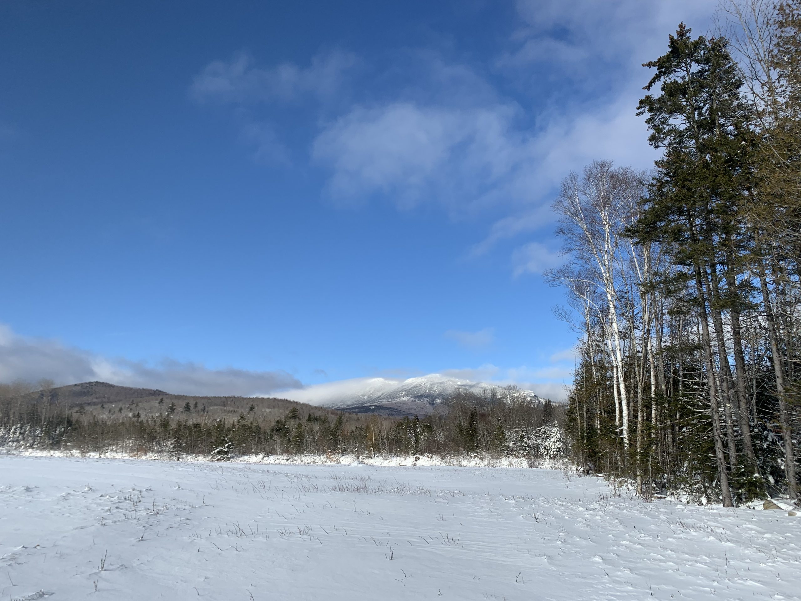
Let’s go! I enjoy striking views from the get-go. Avery and West Peaks, both reaching above 4000’ elevation, rise as a great towering wall against a blue-flame sky. The peaks themselves, in contrast to the brilliant sky around them, are cloud-wrapped. High winds at high elevation shoot a long ragged cloud plume – like the mane of a white horse at full gallop – in the direction of Little Bigelow Mountain. Quite the sight.

In moment I reach the Richard Munzer Memorial Bridge over the Carrabassett River. This is a multi-use recreational trail bridge for foot travelers, and those on snowmobiles or ATV, in season. (No access for other motor vehicles.) On the far side of the bridge, routes diverge. ITS 115 snowmobile trail in one direction; and people-powered routes – the Narrow Gauge and Maine Huts System Trails – in other directions.
I pause on the bridge, scan the river. The Carrabassett thumps, roars, clicks, slaps – the cacophony of river water on its rush from the mountains of Western Maine to the sea at Merrymeeting Bay. Upstream, curiously brown and green hued waters, which close-up, are as clear as clear can be, swing around a heavily bouldered bend. On the downstream side of the bridge, the river races southward for a rare straight stretch, boulders silhouetted by the now-higher sun, before it disappears from sight around a far turn.

At the five-way trail intersection on the far side of the bridge, I turn left, where a sign clearly designates the Narrow Gauge, cross the clear waters of Huston Brook by a broad footbridge, get into my rhythm. Today I am on my classic technique skis – stride and glide, stride and glide. On firm trail topped by a light powder snow, I have conditions as good as they can be.
In its first section, the Gauge runs straight for nearly a mile, while the course of the river angles briefly out of sight. We will meet again, river and I, on this outing. Now my “companion” is not the river, but the mixed growth Maine woods – balsam fir, rock maple, white birch, cedar, beech. New growth following a recent log harvest pokes through the snow cover, as the forest renews.
“Hey there!” An overtaking skier, on skate skis, passes me – an old friend. “Good snow!” he calls. “Hiya, hiya!” I reply, a Norwegian call of ”faster, faster!” to ski racers. He skates his way up the trail marking a v-shaped pattern on fresh, unbroken snow, grows smaller and smaller as he puts distance between us.
Along the way spur tails diverge, left toward the river, right into the low foothills that divide the Carrabassett River drainage from that of Huston Brook. These trails signed and designated on a Carrabassett Valley mountain bike map, (carrabassettnemba.org/trail-maps) serve as bike trails in the warm months, snowshoe routes in winter. Bikers on “fat tire” bikes do use the trails as well – one more way to enjoy the Maine outdoors in winter.

Just under one mile above the bridge I reach a junction with the former “Narrow Gauge Bypass” (That term no longer appears on signage.) signed by Maine Huts and Trails (MHT) as a direct route to the Stratton Brook Hut. (At this writing, Stratton Brook Hut and the other huts of MHT are not open. Check mainehuts.org for updates on proposed winter daytime services at Stratton Brook Hut for 2021, and for trail grooming plans.)
Beyond this junction The Gauge, and the booming river meet again, in a narrow canyon where railroad construction crews blasted ledge to make way for the rail bed. Side streams tumble off trailside rock slabs slope. Icicles catch the morning sun. Quite the display.
I reach one of many picnic tables placed along the way, on a perch between trail and river, where I stop for an apple and water break. 10” of snow covers the bench. I sweep it off, place my foam pad, and savor the music of the river. Other skiers appear, some who like me, began at the Airport Trailhead, and others who started from upstream trailheads off Highway 27 at Campbell Field, or near Bigelow Station at the Stratton Brook Hut Trailhead.
Back on trail I cross a 100-yard bridge spanning a broad bog. Perhaps at one time this bog was an old course of the Carrabassett River. Silence prevails. At another point the river swings westerly, opening up a narrow, gun sight view of the slopes of North Crocker Mountain – another 4000’ peak – in the distance.

I pass an old fishing camp signed, “Riverside 1900”. What would those who once fished here, in this remote spot, think of skiers striding by? For that matter, could those who built the railroad, or who worked on it hauling logs and passengers, have imagined skiers where once there was track – let alone a major highway beyond the opposite shore? Imagine a morning at camp well over a century ago,
People rise early, after a multi-day journey (by train? by horse?) to fish the deep pools of the Carrabassett in the shadow of Sugarloaf and the Bigelow Range – with the occasional roar and clack-clack of the train to break the silence.
The next major trail junction is a 0. 2 – mile side route to Campbell Field Trailhead, with parking area, vault toilet, and trail kiosk with a map. This spur crosses the river by a new footbridge, constructed in recent years to replace one swept away in a massive runoff surge. My wife and I often start from this trailhead in summer and fall to explore the upper reaches of the Narrow Gauge and one of the many side trails along the river.
The Gauge continues its upstream direction, crossing a clearing where views open northeastward to Avery and West Peaks of the Bigelow Range. Here a Maine Huts Trail diverges to ascend to the Stratton Brook Hut on Oak Knoll. To the northwest, the slopes of North Crocker Mountain appear through an opening in the forest canopy.
This well-signed junction, with its Bigelow Range view, is a prospective turnaround point, but I opt to continue to the upper end of the Narrow Gauge, Just as the buildings of the former Bigelow Station area, now a private residential area, come into view, the route makes a sharp left. The route crosses a tributary stream to the Carrabassett, to end at the Stratton Brook Hut trailhead on Highway 27, 0.1 mile beyond the Sugarloaf Access Road. After a trailhead water and snack break, I reverse direction.
Now the fun begins – not that I have not been enjoying the trek to this point.

The “train leaves the station” as I quipped earlier. The return trip is downhill, gravity in my favor. Over long stretches I double pole, work up momentum and “let-em run”. Down, down, down, now in the heart of the woods, now just a few feet
from the boisterous river, now back into the woods, now out again through the sharp canyon, icicles and all, down, down.
As I near the Airport Trailhead, afternoon sun is within an hour of setting. Thin clouds above Poplar Mountain and in the direction of out-of-sight Owl’s Head mountain glow orange, purple, gold – a fine end to a good day on trail.
Foot and Paddle Tips
If snowshoeing is your preferred mode of winter travel, the Narrow Gauge and side trails offer miles of opportunity. Those on snowshoes are asked to walk on the packed surface groomed for skate skiing, and not mar the tracks set for classic technique. Bikers on fat-tire bikes use the trail system, and are to yield to those on foot – but it is a good idea to be alert. The Gauge is popular with dog owners, and because skiers and bikers move briskly, dogs are to be leashed to avoid collisions.
Get to know this area for the fine variety of outings available on or near “The Gauge.” Pack a hearty lunch and make a full day of your outing – year round!
Text and photos Copyright 2020
Doug Dunlap

Doug, what a wonderful article about one of our favorite skiing, biking, and walking trails in Carrabassett Valley. It is a gem in all seasons. You have captured the essence of what the Narrow Gauge has to offer.
I agree with Joe, Doug! We all love this spectacular trail in any season. Thanks for a great article!